.jpeg)
Why Use Drone Construction Photography?
Drone imagery is an invaluable resource, offering a cost-effective, efficient, and highly precise method for visually documenting construction projects from start to finish. These aerial visuals enhance safety, communication, and project management by providing stakeholders with a clear, comprehensive perspective of the site throughout all phases.
Imagine having a bird's-eye view that not only saves time and money but also ensures accuracy. Let's explore how drones elevate project management:
Do you need real-time insights? Our drones conduct routine flights—either weekly or monthly—capturing high-resolution shots that empower project managers with up-to-the-minute progress updates. This level of insight ensures your projects remain on track and within budget.
Looking for smarter planning solutions? The regular capture of aerial photos provides an encompassing visual chronology of the site. These visuals are instrumental in pinpointing bottlenecks, refining workflows, and making informed decisions for future ventures.
Are your current site surveys efficient enough? Our drones can cover large and intricate construction sites swiftly and economically compared to traditional methods, delivering precise data needed for topographic maps and preliminary site assessments.
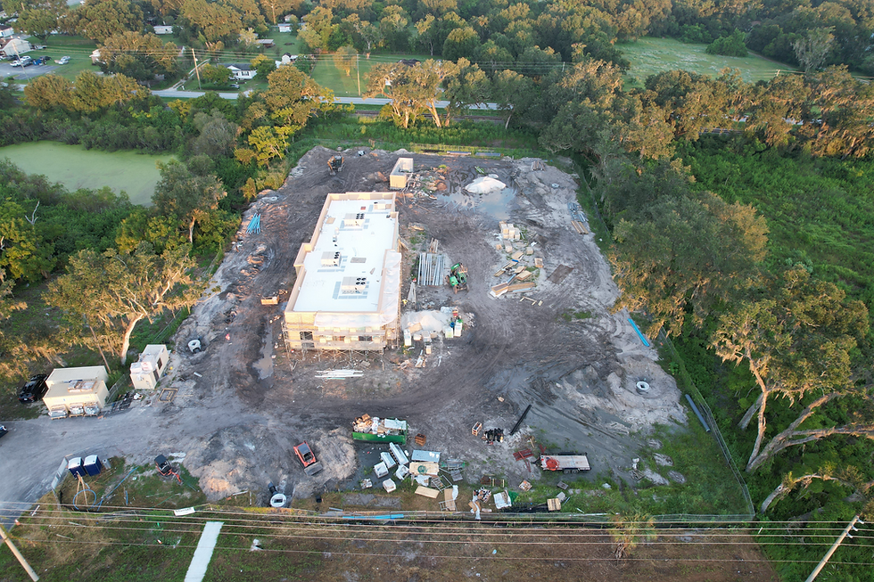
Our drone-captured construction progress photos, as seen in this sample from a six-month Chic-fil-a project, showcase the benefit of incorporating regular drone-based inspections into construction workflows.
Safety & Risk Management
Concerned about safety? Drones reduce the need for manual inspections in dangerous or hard-to-reach areas like rooftops or scaffolding, significantly lowering accident risks and worker injuries.
How proactive is your issue detection? Drone photography can reveal safety risks from previously unseen vantage points, such as poorly placed equipment or unstable structures.
How do you resolve disputes effectively? A detailed visual archive of the site provides objective evidence, crucial for documenting issues and mediating disputes with contractors or other parties.
Communication & Collaboration Benefits
How engaged are your stakeholders? With regularly updated drone visuals, you have a compelling narrative of project development at your disposal. This transparency facilitates clear communication with stakeholders and clients.
Need improved team coordination? With real-time drone data accessible through cloud-based platforms, we ensure everyone—from managers to engineers and subcontractors—stays aligned with the latest visual information.
Ready to amplify your marketing impact? High-quality aerial imagery of finished projects can be leveraged to craft powerful marketing content, showcasing your company’s expertise and final results.
Engage with us today and let’s discuss how drones can be an integral part of your inspection and project management strategy!
Typical Requested Progression Photos
The majority of our clients request pictures capturing the entire site from each cardinal direction (North, South, East, West) and from various elevations—50 ft, 100 ft, and 150 ft. It is also common to request a bird's-eye view taken from 250 ft, looking straight down. If you require something different, please reach out, and we can customize our flights to meet your needs.
What To Expect
If you're located within a five-mile radius of an airport, we might need to seek a waiver from the FAA to conduct your flights. We want to assure you that at SkyScope, we have extensive experience navigating FAA procedures to secure necessary clearances. It's worth mentioning that this process could take several weeks, depending on current FAA workloads.
Before Your Appointment
01
After booking your appointments with us, please review and sign the emailed inspection agreement. This crucial step ensures that your inspection is fully confirmed and ready to proceed. If you sign up for weekly, biweekly, or monthly service, we will schedule the flights for the entire construction schedule season dates on the initial agreement. This one-time signing will cover all visits to the property.
On Flight Day
02
Due to the nature of drone flights, the inspector does not need any access to the physical site, as the drone can take off from an adjacent parking lot and complete the flight. This feature enhances safety by reducing the number of people accessing the construction site, even for inspection purposes.
Receive your detailed report
03
Following each flight, you will be sent a report, accessible once the inspection fee has been paid in full. Some clients prefer to pay upfront for the entire flight package.
If you are undertaking a 6-month construction project and would like weekly flights, the price is $150 x 24 weekly flights = $3600. This can be paid upfront or in weekly installments after each flight.